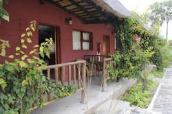
| Situated in the heart of Nata, amongst a
forest of Llala Palms en rout to the Okavango Delta or Chobe Game Reserve
this is the ideal stop over after a long journey, or a great way start
a new adventure.
Alternatively, make us your base to spend your days exploring the plentiful
places of interest in this vast, untapped beauty of Botswana, including
game viewing, bird watching, camping, and much, much more. Enjoy five
star European style cuisine (or be adventurous and try the fantastic traditional
cusisine), ice cold drinks from the fully stocked bar, or just relax by
the cooling waters of the our sparkling pool.
email: nata@go.botswanatravelservice.com
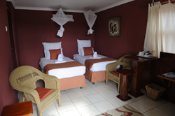
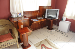
Accommodation at Northgate Lodge Nata
Chalets:
Our chalets comprise of the following:
Single beds
Bathroom/Shower
Television
Tea kettle
Mosquito Net
Ceiling fan
Executive Rooms:
2 Single Beds or One Double Bed
Bathroom/Shower Or Tub
Television
Tea Kettle
Mosguito Net
Air Conditioner
Family Rooms:
2 Bed room
1 Double Bed and 2 Twin Beds
Bathroom/Shower Or Tub
Television
Tea Kettle
Mosguito Net
Air Conditione
Activities:
Experience The Emptiness Of The Makgadikgadi Pans:
The Makgadikgadi Pan is a large salt pan in Northern Botswana, the largest
salt flat complex in the world. These salt pans cover 16,000 km2 (6,177.6
sq mi) and form the bed of an ancient lake that started evaporating 10,000
years ago. The area is home to one of Africa's biggest zebra populations,
and usually only quad bikes are permitted on the fragile plains in single
file. Makgadikgadi is technically not a single pan but many pans with
sandy desert in between, but it is all counted in the area estimate. The
largest individual pan is about 5,000 km2 (1,930.5 sq mi), and it is frequently
covered with water. Salar de Uyuni in Bolivia on the other hand is a single
salt flat of 10,582 km2 (4,085.7 sq mi) and rarely has much water and
is also claimed to be the world's largest salt pan. Commercial operations
to mine salt and soda ash began in 1991. The main water source is the
Nata River, called Amanzinyama in Zimbabwe where it rises at Sandown about
60 km (37.3 mi) from Bulawayo. Kubu Island, a rock island, is within the
Makgadikgadi Pan
Nata Bird Sanctuary:
This sanctuary was established in the early 1990s on the far northeastern
edge of Sowa Pan and, apart from the Makgadikgadi and Nxai Pan National
Park, is the only protected reserve in the area. It is a local community
project managed by a board of trustees selected from four nearby villages.
This 230 sq km community project is designed as a refuge for the wildlife
on and around Sua Pan (45% of the reserve is in the pan). The idea was
first raised in 1988 by the Nata Conservation Committee and the sanctuary
was realised four years latter, thanks to the Kalahari Conservation Society
and funding from national and international organisations. Local people
voluntarily relocated 3,500 cattle onto adjacent rangeland and established
a network of dust roads. This unique approach to community involvement
in eco-tourism is considered to be the key to conservation throughout
Africa.(from here)
Greens Baobab:
Two places of historical interest are Green's Baobabs and Chapman's Baobabs.
Traders and explorers flocked to the area and amongst them were Anderson,
Cummings, the Green brothers, Chapman and Baines. One of the major routes
for these traders and explorers ran through the narrowest section of Ntwetwe
pan. The only evidence of the hustle and bustle of early traders, explorers,
missionaries and thieves are the names inscribed on the Baobab trees.
The growth of the trees have obscured many of the names, but on Green's
Baobab "Green's Expedition, 1858-1859" is clearly visible. Approximately
11 kilometers South of this enormous baobab is a magnificent, seven stemmed
baobab tree known as Chapman's Baobab or the Seven Sisters. There are
a multitude of names on this tree, and Chapman's name is indicated by
his initials "J.C.". This colossal specimen, visible from great
distances across the pan, is worth seeing if only because of its size
and photogenic qualities. It was used as a landmark for the early explorers
of the region.
Chapmans Baobab:
About 11km further south of Green's Baobab is the turn-off to the far
more impressive Chapman's Baobab, which has a circumference of 25m and
was historically used as a navigation beacon. It may have also been used
as an early post office by passing explorers, traders and travellers,
many of whom left inscriptions on its trunk.
See the Fossilised Dune of NtwetweÂ:
In the middle of Ntwetwe, on the west of the usual north½south
route across the pans, Gabasadi Island is a low mound protruding from
the surface of the pan. It's actually a fossilised, crescent-shaped barchan
dune, which you'll realise if you climb it.
Kubu (Hippo) Island:
Rising no more than 20m above the Sowa Pan, this national monument with
its fossil beaches, stunted baobab trees and mysterious stone walls, leaves
an indelible impression upon all who visit its water-worn shores. This
scrap of rock and its ghostly baobab trees is surrounded by the sea of
salt.
In cool weather, this bizarre sight can make visitors feel like castaways
on an alien planet. The real name of the island, but less known, is Lekhubu
(meaning ridge in Setswana). It is the most famous of all the rock islands
in the Makgadikgadi. Most of the rock islands in this area are remnants
of ancient sand dunes. Kubu Island is different in that it is one of the
scatterings of granite islands. Many of Kubu's rocks are stained white
with fossilized bird droppings. This ancient guano is called apatite and
bears testimony to a large bird population that used to live on the island,
feeding off the fish of the waters that surrounded their rocky knoll.
There is a trig-beacon on the island's summit. The rocks on the northeastern
side are all smoothed by wave action, while on the opposite leeward side
are thousands of small, rounded pebbles, which used to protrude as a tiny
wave-washed beach. As the level of this immense inland sea rose and fell,
there were times when Kubu was deep beneath the waves, others when it
lay exposed in a sea of sand and others when it hardly showed above the
surface, surrounded by 100km of sea. The island is littered with artifacts
from other ages: Stone-Age cutting tools, shards of pottery at least 2000
years old, and the remains of a low, circular wall.
Village Tours:
See the Kgotla, have traditional Magunya made for you, see the clinic
and school, ride in a donkey cart, HAVE FUN!
Northgate Lodge Prices |
Prices are per |
| |
|
 Botswana Travel


